Missisquoi River
No other single factor has influenced the development of Sheldon Junction, VT as has the Mighty Missisquoi River.” This 80 mile long river beginning in Lowell, and crosses into Canada at North Troy, re-entering the US at East Richford and crosses about 11 miles of Sheldon with the town claiming the longest section of any of the 12 towns through which the river passes with approximately a half mile in the area referred to as “The Junction”. No other point along the route is known to contain as many attempts to cross via a bridge as the Sheldon Jct. area with up to 7 attempts to master the river. In addition and prior to the Plank Road bridge fording points provided crossing of the river and at least two ferries are known to have been in service.
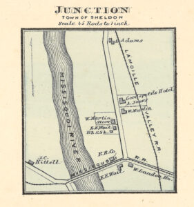
On the map above from 1871 several Junction items stand out but the bridge is shown along with the home of the toll keeper Mr. E.E Waite.
Settlers lived on both sides of the necessitating crossing to the other side. Temporary bridges of tall pines with plank roads, lasting less than a year until the spring floods took them out. Not until the 1830s, some 40 years into the settlement of the town, did the settlers choose to challenge the power of the water that provided them with energy while presenting a transportation challenge.”
The Plank Road Bridge
Saint Albans Weekly Messenger June 14, 1849 reported “The inhabitants of the county of Franklin are hereby notified that a plank road is to be completed through the Town of Sheldon”
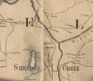
On the 1857 “Walling” map to the left note the rivers and the roads. At the point where the Plank Road from the left approaches the river the crossing is labeled Toll Bridge”
“Several fine bridges span the Missisquoi at different points; but the immense amount of teaming that passes over them, especially during the rains of fall and spring, cut them up badly. Probably there is not a valley in Vermont – I might say in New England – where there is hauled, up and down, so much freight, produce, goods, etc., as in Missisquoi valley. To obviate or alleviate this in a measure, a few years since a plank road was built from ST Albans to North Sheldon, a distance of about 12 miles, costing $50,000. The bridge across the Missisquoi alone cost $15,000. It has 4 arches, 5 piers, and is 640 feet long”
Whitney, Tolman, and Bailey
“The History of Sheldon VT.” 1872
The Main Street Bridge
In 1887 the State constructed a bridge across the Missisquoi River near Sheldon Jct. The “Main Street bridge cost was approximately $13,000. The bridge fell in the flood of 1927. After the flood of 1927 the Vermont Construction Co; built a 2 span wrought iron double intersection Warren through truss bridge at the same location. It was demolished and not replaced after the 1946 flood.
 A flood in 1946 took out this bridge. It spanned from Sheldon Jct. between the CVRR bridge and the LVRR bridge and joined what is now the “Casino Road” with what was then Main Street. The abutments on the east side of the river continue to give evidence of its existence.
The currently existing concrete bridge over the Missisquoi along the Rte. 105 corridor was re-built in 1947
The Missisquoi Railroad Bridges
(Also called the Central Vermont Railroad Bridge)
The Missisquoi Railroad was chartered in 1869, and a survey was made at once and the work of construction followed, the road being completed in 1870. The first train from Sheldon was on the fourth of July, 1870, and regular trains were soon put on. The railroad spanned the Missisquoi at Sheldon Jct. via a covered bridge that lasted until it burned in 1900.
“The Central Vermont railway bridge over the Missisquoi River at Sheldon Junction was burned this morning shortly after 10 o’clock. It was the longest bridge on the Missisquoi division of the Central Vermont and though built of wood was valued at approximately $15,000, having cost much more than that originally. It was 459 feet long in three spans of 147 feet and 6 inches each with necessary approaches, and was what is called a through wooden or covered bridge.
With its increasing age the time was near at hand when it would eventually have been torn down and replaced by a more modern steel structure.
How the fire started is not accurately known but undoubtedly from the sparks of a locomotive. An excursion train bearing a large number to the Wallace circus in St. Albans had just passed over it as well as the regular passenger train which arrived in this city at 10:30″.
St. Albans Daily Messenger, St. Albans, VT 14 Jun 1900
The St. Johnsbury and Lamoille Railroad Bridge
The Lamoille Valley Railroad was chartered by the Vermont legislature about 1867, and the following year a survey was made, but not being satisfactory three or four more were made in order to ascertain the most feasible route. Work was commenced in 1870, but owing to a lack of funds and financial crash of 1873 the road progressed slowly, the principal expenditure being made in advertising for help and getting them to work as long as they could by promises, and giving them plenty of tobacco and a few necessities. They would thus keep the help for about two or three months. The cost to the company through this town was only about $3,000 to the mile till they were ready to lay iron. In 1877 the road was completed and the first train passed over it July 27th, and soon after regular trains began run. There are only about four miles of track in the town, and two stations, one at the village and one at the junction with the Missisquoi Valley Railroad.
History of Franklin and Grand Isle Counties, Vermont
edited by Lewis Cass Aldrich (1881)
A limited timeline of flooding at the Junction
For over 200 years the Missisquoi has challenged riverside residents, the Town of Sheldon, and the State of Vermont with nearly annual flooding at the Junction.
1897 Without details a report in 1901 states “The River has not been so high since the flood of June 14, 1897”
1890 “The Richford Journal and Gazette” reported on a rare summer storm on July 10, 1890. Among other details reported, “The long railroad bridge at Sheldon Junction was racked by heavy wind, the track being 14 inches out of line.”
1900“The St Albans Daily Messenger” Feb 15, 1900 reported “The highway around Sheldon Junction was completely filled with ice yesterday and a large force of men worked all day and last night clearing it away.”
1901 “The Burlington Free Press” March 3, 1902 reported on the flooding of December 4, 1901. The high water mark was reached and it took out the Bouchard Road bridge which went down stream and riding on the ice rammed into the state bridge..“S M Reed moved his family out of his house about noon as the water was about two feet deep around his house.”
1901 The “Burlington Free Press” March 28, 1901 reports on flooding of the valley. “The ice began breaking up in the Missisquoi River this morning and a big ram formed near Sheldon Springs, throwing the water back four miles completely flooding all the low lands, and interval farms in this section, covering them with ice and flood wood. One span of the trestle at the railroad bridge here was taken out and it looked for a time as though three other bridges must go. The ice was very thick and was thrown against the St Johnsbury and Lake Champlain railroad bridge with such force that the boarding was broken. —The water is 24 inches deep in the barn of W H Dunton.”
1927 The 1927 record flood goes without further mention as reported by the National Guard “The great Mississippi River flood of 1927 was one of the worst natural disasters in American history. It inundated 27,000 square miles, an area about the size of New England, killing as many as 1,000 people and displacing 700,000 more.
1960 Although numerous floods occurred before 1960 “The St Albans Daily Messenger” reported on April 1, 1960 “Ice jams ad rain caused the Missisquoi River to back up onto the meadow lands in Sheldon Junction.”
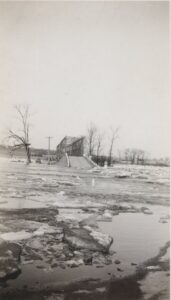
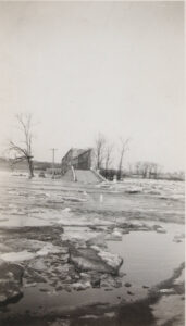
On Feb 27, 1961 “The Burlington Free Press” published a photo of the John Bergeron farm in Sheldon Junction with Missisquoi River water surrounding it while reporting that “Three Daily Farms Evacuated At Sheldon A Food Rises” The John Bergeron farm, the Chadwick farm and the Carlton R McEnnany farm were each evacuated by State Police and residents while water reach a depot of five feet at the underpass.”
1980s As a Sheldon resident during this time I recall looking at river flooding in the Junction from the top of the hill on Main Street on many occasions. It appeared to be a brief but almost annual event.
January 25, 2018 St Albans Daily Messenger The Missisquoi is reported to have risen over 10 feet during flooding along its entire length in Franklin County.
July 2023 & 2024 Historic flooding occurred in Vermont both years due to heavy rains. Sheldon Junction flooded during this time.
October “Halloween” flooding of the Missisquoi River reported on WCAX TV
Reports, photos, and videos attest to the challenges that the Missisquoi continues to present to individuals choosing to live on the river in Sheldon Junction. Although less intense in some ways the impact continues to influence the settlement with fewer residences and no stores.