Touring The Eastern End Of Sheldon, Vermont
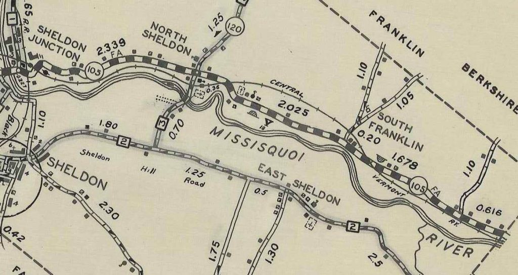
This tour of Sheldon begins at the intersection of Vermont Routes 78 & 105 and proceeds along the north side of the Missisquoi River to the Enosburg Falls town line. Separate devloped pages are linked to for ease of navigation. The map below clearly shows 105 traversing North Sheldon, South Franklin and into Enosburg. An alternative route along thte south side of the Missisquoi River proceeds from Shelon village past the Kane Road through East Sheldon and into Enosburg at Duffy Hill Road. That portion of Sheldon history may be explored on our East Sheldon page.
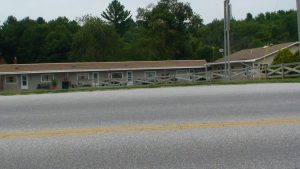
In 1964 Phillip Bergerson built “Country Motel” at the intersection of Rte. 105 & 78.
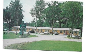
During the 1960s travel and tourism sponsored economic development to accommodate tourists. Littered along rural highways abandoned motels and diners testify to this era. This one survived by being turned into apartments.
Contunue east on Vermont Rte. 105 and turn into the Casino Road. Nothing remains of the once active and highly popular “Sheldon Fair” ground. This significant era in our history warrants a page of its own and is included within our displays at the Shedon Historical Museum
Dairyland – The Abbey
Proceed east and soon you arrive at the “Abbey” restaurant purchased from Homer Fairbanks by David and Sherry Underwood when “Dairyland” continued as a local hot spot. The Underwood family transformed the business into a highly reputable family restaurant and banquet hall.
An arial view of “Dairyland” with the Missisquoi river in the background and Rte. 105
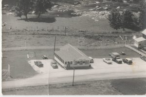
Homer Fairbanks owned the farm on the north side of the road. As his daughter says he was a “Wheeler and Dealer”. In the early 1950’s on a trip he passed through Jericho, VT and discovered a “Creemee” stand. Upon seeing a business opportunity and a means by which to provide summer employment to his daughter and her high school friends he proceeded to New Hampshire and immediately purchased an ice-cream making machine. Upon returning home he constructed the first “Dairyland” as an ice-cream stand that eventually evolved into a full service restaurant. The current Abbey building incorporated parts of the “Dairyland”.
“Around The Project” published by the Vermont Electric Coop in September 1952 featured an article about Homer and his Dairyland venture. “Around The Project” represents a rare find given to us by Homer’s daughter Jane and is on display at our museum.
On our way to “North Sheldon” on the north side of Rte.105 sits the Philo Marsh House built around 1855. North Sheldon at the intersection of Vermont Rte. 105 & Vermont Rte 120 and the Kane Road developed over time as the halfway point between St Albans and Richford,VT. Click the link above to explore this historic hamlet.
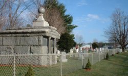 Drive east along Vermont 105 and on your left after passing trhough the S turn and just before the Hartman Farm Stand you will observe the Gallup or Missisquoi Valley Cemetery established in Nov. 1898. A fence surrounds the property and no additional burials are schduled.
Continue driving east of Rte. 105 and almost immediately on your right is the site of the former Riverside Campground..
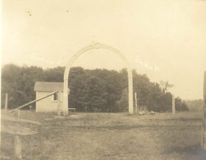
Established in 1882, it has been known as the Riverside Camp Meeting or Sheldon Camp Ground and eventually Camp Missisquoi. It included tent sites as well as permanent cabins. The Grove House became a dormitory as well as the kitchen and dining hall. A large concrete pool, built in 1955, provided swimming and a nurse’s building provided health and safety. The large open air Tabernacle built shortly after 1900 housed many worshippers during multiple services.
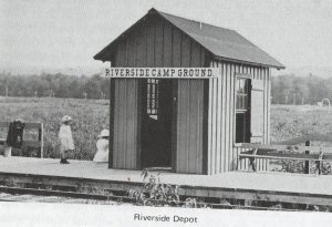
Campers arrived by car and also by train with a separate seasonal train depot on the Central Vermont line.
 Parking at the east entrance of the campground provides you with a view of the former Andy Bonneau Farm and Agricultural business. Its significance is measured by its value in providing a temporary venue for the Sheldon Fair. Between the ending of the Fair in 1931 and the operation of June Dairy Days beginning in 1956, and prior to moving to its permanent location in Enosburg Falls, the festival was hosted by Andy at his family farm for a few years. June Dairy Days continue to thrive as one of three festive Franklin County events throughout the year.
South Franklin and The State Park Road (236)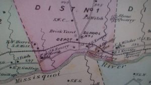
Beers Map of 1871
This busy intersection “known as South Franklin”but did was known as District 1 because of the location of the District 1 School. The town prior to this was divided into school districts with one room school houses providing an education to students in grades 1 to 6 at a location within a 2 mile walk of their homes. The Depot (shown on the map) was one of the CVRR stops on the way to Richford. Two springs appear on this map. They have not been rediscovered in our most recent 2017 search. Both Excelsior Springs and Mineral Springs apparently disappeared when the new VT. Rte. 105 corridor covered them over.
In 1871 the town constructed a covered bridge over the Missisquoi connecting the South Franklin Road to the East Sheldon Road. The road, south from the bridge, exists today as a farm road leading to the Stebbins place in East Sheldon and near the former location of the Union House at the Rock where religious meetings occurred. This three-span covered wooden bridge lasted only 7 or 8 years. The floods of 1888 or 1889 destroyed it and it was never rebuilt. No one ever photographed the bridge and no physical evidence remains such as piers or rock piles.
As weTtavel east from the Rte. 236 intersection towards Enosburg Falls we drive through farming country with many established farms and at least four historic homes as cited in the 1980’s publication “Historic Sites and Structures Survey – Sheldon” available at the Sheldon Historical Society.All houses are found on the north side of Rte. 105 along with adjoining barns and structures. The fertile Missisquoi River Valley to the south of the highway remains devoted to crops.
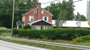 The Beatty House built around 1830
This historic home erected in 1830 was known as the Beatty House. The current Rte. 105 road makes it dangerous to stop on the road to see the house. The trees hide it to some extent but the Missisquoi Valley Rail Trail runs directly behind the house and barn and is easily accessed from Rte. 236. Along this short walk the old private cemetery known as “The Hammond Cemetery” may be visible on the top of the hill behind the house and barn The property has continued to be a family dairy farm over the years.
“This is one of Sheldon’s most impressive Federal houses and despite some additions, is the quintessential expression of the style as seen in rural areas. It is probably also one of the town’s oldest farmhouses.” UVM 1982
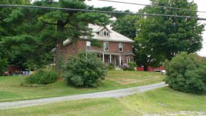 Kane-Stebbins farm originally the EJ Wilder farm built around 1901
“This farmhouse is certainly rural Sheldon’s most impressive example of Colonial Revival architecture. It has, in addition, to some notable Queen Ann details including numerous stained-glass windows. Also significant is an original and well kept corn crib.” Built around 1901 the farmstead originally provided shelter to the E. J. Wilder family. Mr. Wilder was a successful dairy farmer. Current occupants are the Kane and Stebbins-Kane family who are also successful farmers.
The Clark Cemetery
A private cemetery on the property known as The “Jedediah Clark” cemetery held the remains of Revolutionary General Jedediah Clark along with several other family members. Its restoration remaind doubtful..
The Longe House and Barn originally the Towle house built in 1850
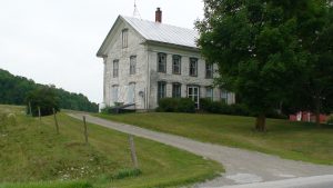
This house is a good example of late Greek Revival architecture and retains much original detail.” UVM
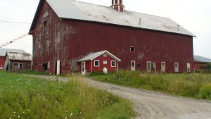 “The barn is an interesting, architecturally, notable for its Italianate cupola and corner pilasters.” UVM
Built in 1860, it is 2 ½ stories with an 8 sided two stage cupola. This remains one of the more unique barns in all of Sheldon.
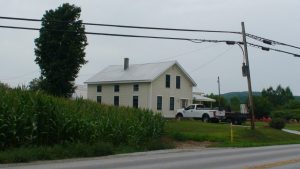
The Parent House former known as the Burt House built around 1892
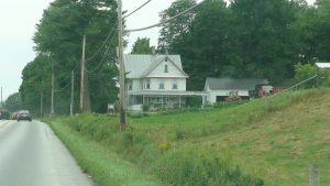 “This house was built by the Burt family to replace an earlier farmhouse. The family has lived on this site since the 1850’s, and were the founders of Leader Evaporator in St. Albans. The house is a nice example of vernacular Queen Anne style, one of the best in rural Sheldon. It retains much of its original appearance.” UVM
Opposite this home the Missisquoi River meets its tributary “Tyler Branch” and is the location of the original “Sheldon” settlement long since abandoned.