North Sheldon
Continue east on Rte. 105 to the Rte. 120 intersection and turn right onto the Kane Road. ”Dodd’s Corners”, by current recognition, officially remains known as “North Sheldon”.
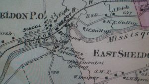
Beers Map 1871
North Sheldon thrived during the early history of Sheldon and boasted a school, a hotel, a post office, a rail depot, a cheese factory and creamery, a cemetery, and many residents by the surname of “Fish” many of whom remain in the North Sheldon Cemetery. “Continental Springs supplied water to farmers. The village of Sheldon could be accessed by the now defunct road along the south side of the river.
Covered Bridge at North Sheldon
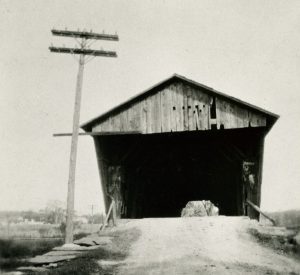 A 180 feet long covered bridge was constructed at North Sheldon about 1860. It served
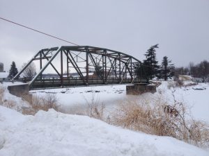 the Town of Sheldon until it was destroyed during the flood of 1927. This serves as a vital link between Sheldon and Franklin and currently utilizes a new steel truss bridge.
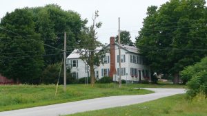 Presently the RTE 105 and 120 intersection is known as “Dodd’s Corner” owing to the large Dodd farm on the corner. The parents of Russell Dodd purchased what was known as the Strait farm in 1945 and sold it to Russell and Eleanor James Dodd in 1955 and it continues in the Dodd family. This home was built in about 1845.Originally it was known as the “Daniel” Fish house and is on the Beers map of 1871.
Thr Dodd House
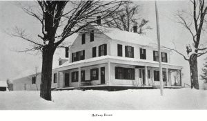 An early photo of the same property in winter labels it as the Halfway House. A Halfway House existed between St. Albans and Richford and was likely at this location where the former Plank Road ended but we are not able to substantiate that. A clipping from the St. Albans Messenger dated June 14, 1849 states: “The inhabitants of the county of Franklin are hereby notified that a plank road will soon be completed through the Town of Sheldon in the center of said county.”
An article appeared in the Burlington Free Press on January 16, 1941 addressing the signficance of this house in the history of Sheldon.
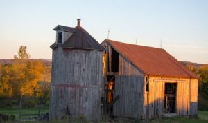
The Dodd Barn
 A small house occupied the south west corner of the intersection but it burned in 2017 leaving an unoccupied barn opposite as shown here. The history of the barn and land stretch back into the 1800s with an 1899 deed establishing its location bound on the south by the Missisquoi River, one the east by John Fish and C.A. James, on the west by Charles Butlet and on the north by James McFeeters. Clinton & Ethel Beebe owned it then and the total farm was 171 acres.
Built on the now defunct Missisquoi Valley Railroad line (1843-1995, a branch of the Central Vermont railway), this barn is the only remaining structure of what was once a thriving farm and rail station complex. The original compound included a cattle yard, milking barns, carriage barn, farmhouse, hotel, and train station. In 1910, a spark from a passing train ignited a fire that destroyed all but this small cow barn with its rare coopered wood silo. In 1962, Russell Dodd purchased the land and barn to start his dairy operation with 30 heifers. The structure was used for milking cows right through the 1990s. Since the 1960s, 5 generations of the Dodd family have run their dairy business on the land. They now milk 300 cows in their modern barn across the street. The small wooden barn now sits alone in a field and is used only for hay storage.
A local business woman purchased it and has begun restoration.
Continental Springs House
“Continental Springs located on a hill to the south and east of the village supplied water to a spring house locate near the creamery on the east side of the “Kane” road. Farmers and residents used the spring water. A story related to us by an older Sheldon resident recalls the day he and another person retrived a dead cow from the spring house. His age at the time of 16 would indicate that the spring was still in use into the 1950s.
North Sheldon Post Office
 Postal Artifacts from the North Sheldon Post Office Collection
Additional Details are available on our Postal History Page